Friday, September 29, 2006

internet mapping proposal

i would like to attempt to map the internet. i think that it would be interesting to map the connection between the virtual world of the web and the geographic location of the data. the route that data takes as it travels from a server to the end user on the web can be map. i propose to map these routes from various location to the clemson network, which will serve as the base point of the map.

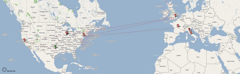
below are a few examples of the traceroute operation. the ip addresses compared to a database of geographic locations and then mapped using google map. these maps were generated by mapulator, which seems to have a minimal geographic database. i plan to create a simple webpage that could access a larger geolocation webpage and generate maps using the google map api.

here are the maps:


germany to clemson


switzerland to clemson


japan to clemson


texas to clemson


pennsylvania to clemson

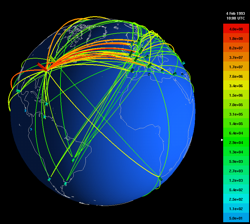
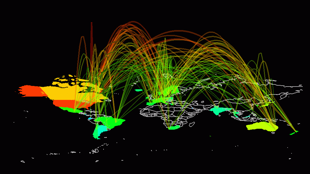
here are some examples of similar maps:

map of global traffic


global internet traffic

Wednesday, September 27, 2006

the internet

the internet has a very complicated history that begins in the 1950s. but first, it is important to properly understand terminolgy, specifically the meaning of 'internet' vs. 'world wide web'. the internet is the collection of interconnected computers and computer networks linked by physical connections (telephone lines, ethernet cables, fiber-optics cables). the world wide web, which is often mistakenly called the internet, is a collection of documents and resources that exist in the virtual world and are interconnected by hyperlinks and urls. in other words, you can view documents on the world wide web because you know there unique web address (url) or because you link to them from another web page, which is often a web page dynamically generated by a web search engine, like google. these documents and resources, which are located on computers around the world, are available through the internet.

now a brief history of what we now call the internet. the first computer networks began to emerge in the 1950s, epescially in government agencies and universities. these network connected computer terminals with direct, dedicated lines (even over great distances), allowing for intra-netting. by the early 1960s, national security concerns and the desire to allow researchers in different geographical locations to share resources and ideas created the need for inter-netting. J.C.R. Licklider theorizes on the idea of an 'Intergalactic Network' where people can access data and programs on one computer from any other computer anywhere else in the world (or galaxy...he was quite the visionary). The early internet pioneers faced two key challenges: how to efficently move data and how to overcome the lack of standardization among computer hardware and software used on each individual network.
Paul Baran, Donald Davies, Leonard Kleinrock address how to move data. They develop the notion of packet switching. When data is sent from one computer to another, it is broken into small packets of information which are routed from the source to the destination computer through various nodes. If one of these packets is lost in transmisison, it can simply resent from the source, and therefor the entire transmission is not lost. becuase a didicated line is not required for the duration of the transmission, packets from diffenent sources bound for different destinations can be sent across the same communication line, which maximizes bandwidth. packet switching also allow for complete decentralization of the internet. it is plausable that each packet in a transmission could take a different route to the destination. also, as the architecture of the internet changes, data can still move through it without reinfrastructing.

the first internet was the ARPANET developed and managed by ARPA (advanded research projects agency), an agency of the u.s. department of defense. ARPANET went live in 1969 and had four nodes: ucla, us santa barba, university of utah, and the stanford research institutue.

the following is the map of arpanet in 1971:


and then the ARPANET in 1980:


increases in technology and demand for internetting caused the internet to continue to grow. various other networks were created and integrated. standards were implemented to allow these various networks to interconnect. in 1990, the ARPANET was disbanded as it had been rendered obsolete by other networks.

the growth of the internet (charts show the number of internet hosts):

today, there are 1,086 billion users connected to the internet. this represents roughly 16.7% of the worlds population.

a map of the interet (just in north america):


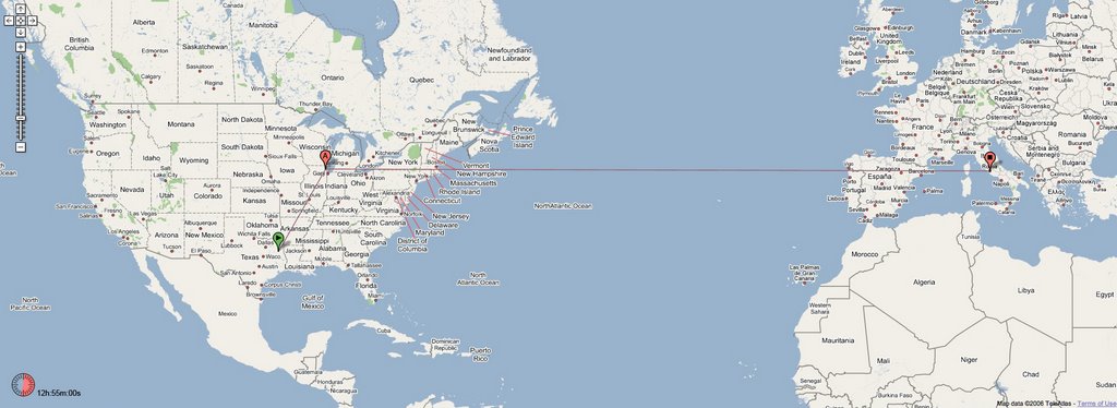
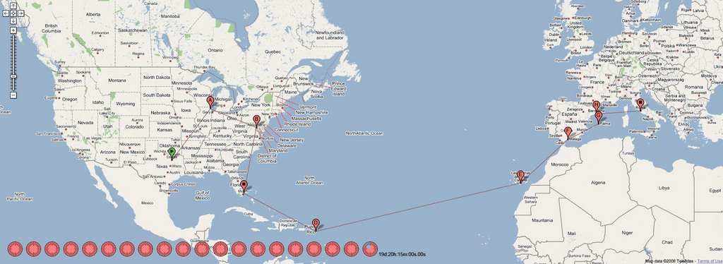
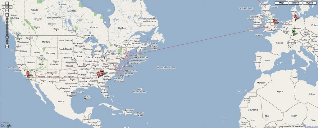
as we all know and experience daily, the internet allows for information to be exchanged at a blinding rate. rarely, however, do we consider the geographic movement of our data transfers as them move through the internet. below is a map that traces the path of data from dallas texas to tuscany, italy (generated by traceroute). it represent the shortest path between the two points at the time of the trace.


below is the same route by traditional means of travel:


air travel


land + sea


some great links:
internet history
internet maps

Saturday, September 16, 2006

pod latch

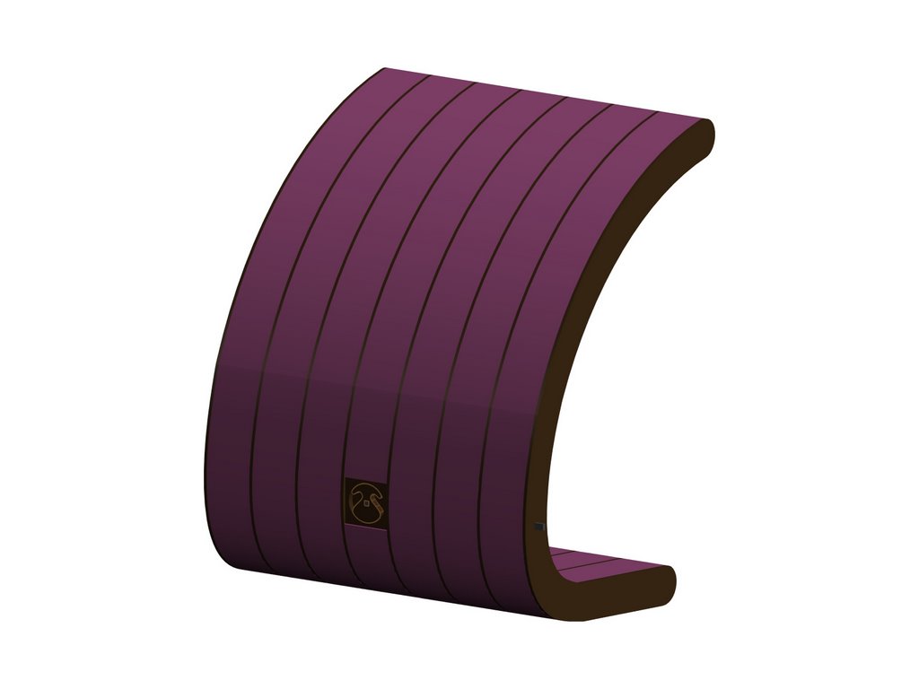
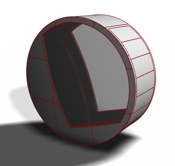
this is what we were thinking for the door latch. we need the latch for two reasons: to hold the door/desk shut while the pod is being occupied and to hold the door/desk shut when the pod is being rolled. the challenge we to design a lock that could be operated from both side with the same mechanism. we chose to implement a mechanism similar to a garage door lock which had a rotating handle that drives two rods into the 'jambs' at the side of the door. we shaped the handle of our lock as a derivative of the overall form of the pod.


exterior of door


interior of door


close-up of lock


lock mechanism (concealed within door)

Friday, September 15, 2006

city + dam

china's three gorges dam is the largest hydro-electric dam in the world. at 185 meters tall and 2,309 meters across (included in the ship lifts and locks), it is five times the size of the hoover dam and is the same length as the golden gate bridge in san francisco. construction began in 1993. the reservoir behind the dam began filling in 2003, and should reach its capacity of 39.3 billion cubic meters by 2009, when all of the construction will be complete.


three gorges dam compared to hoover dam + golden gate bridge


the cost of the dam was staggering. the original budget was around 25 billion USD. however, it is expected that the final budget could be in excess of 100 billion USD (there have been no official statistics released). at full capacity, the dam will generate 85 billion kilowatt hours of electricity annually. when the dam was designed, it was thought that this would provide 10% of china's electrical needs. however, china's economy has boomed since the dam was designed. in light of the higher demand for energy, the three gorges dam will only be able to supply 3.88% of the china's electrical needs. the dam could, however, provide enough electricity to fulfill the combined needs of ireland, peru, north korea, and croatia. although its impact will not be as great as initially planned, the dam will have a generally positive effect on the environment. currently, 80% of china's electricity is generated by burning coal, which creates an immense amount of air pollution. the dam will affect a net decrease in coal consumption of 40-50 million tons. as a result, china's discharge of carbon monoxide will be reduced by 10,000 tons.

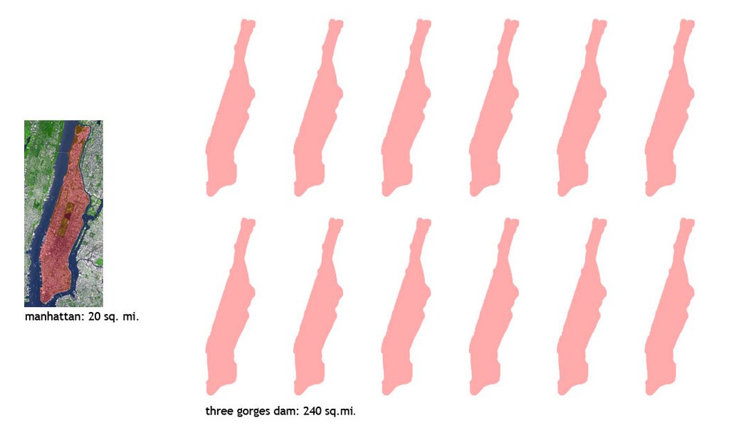
the greatest impact of the dam will be felt upstream. approximately 244 square miles will be flooded when the reservoir is full (i.e. the reservoir will be 2.75x as large as lake hartwell and 12x as large as the island of manhattan). over one million chinese in 1200 villages and two major towns have been or will be displaced. critics argue that the chinese government has underfunded the relocation effort, as those who have been displaces are often given poor quality land on which they cannot sustain. as a result, many have resorted to begging, garbage collecting, and prostitution.


reservoir area comparison

the three gorges area is also a cultural treasure trove. the area was first inhabited over 2 million years ago. a last minute effort has been made by the chinese government to save the 1,200 known archaeological sites, but it seems that it may be too little, too late. experts claim that the the chinese government had provided only 10% of the funds necessary to properly excavate and preserve all the archaeological sites soon to be flooded.

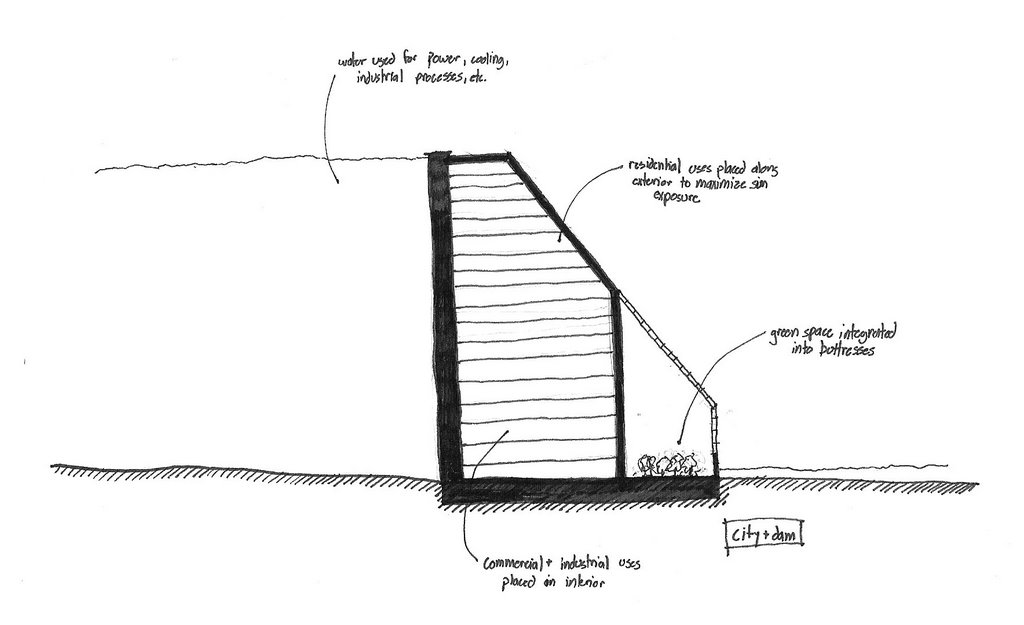
the only way to avoid the loss of artifacts would have been to reconsider the location of this dam. however, the problem of relocating the people could possible have been solved with a mega-solution. is it possible for the dam to become a city, to be constructed so that it could be inhabited. the flow of water could of course generate all the electricity this dam could use. it could also serve to irrigate green spaces and farming operations that could be incorporated into this mega structure and could also be used for thermal cooling and industrial processes.

Wednesday, September 13, 2006

daily thoughts - 09.13.06

i thought that studio was really productive today. i liked having time to work in the beginning of studio with a short conversation with ron at the end of the studio. it seemed that this was much more productive than an early meeting with a short charette in the middle of studio.

ron may also recall an outburst of laughter last week in one of our meetings. the screenshot below shows the cause of the laughter. since ron indicated his diabolic intentions today, it seemed fitting to post this screenshot.

Wednesday, September 06, 2006

a/v1.1

in a quick charette with members of other teams, we made modifications to the a/v proposal. see these changes on melissa's blog and mandi's blog.

a/v1.0

Nicole and I have developed a proposal for one contained unit that can be rolled to any destination:


Once in place, legs fold down to secure the pod in its location:


The top hinges up to allow the student to enter the pod:


Once inside, the student can close the flap to view the video screen, which is also visible to those outside of the pod. The translucent portion of the pod allows light in so the camera is able to see the student within the pod. The bottom flap remains open to allow leg room for students, allowing for the different heights of the students in the class.


This proposal also contains the possibility of a detatchable upper flap, allowing the video screen to be set up in another location for conversations involving the entire class.